We were supposed to sit with the Please Talk With Me About Race sign in a Detroit park. Michigan was our last stop on this leg of the Meet Me Halfway book tour and Detroit is the second most segregated city (or sometimes first, trading places with Milwaukee in any given year), so taking the pulse of racial dialogue here seemed an essential part of our job. A steady rain thwarted us. It’s hard enough to get people to approach the sign in sunny weather. Even if we didn’t mind sitting the rain, nobody was going to stop to talk.
When I gave a reading at the Mattapan public library, on the outskirts of Boston, a Michigander was in the audience. He told us that the word among white people in the Detroit area is, “Don’t live below 16 Mile Road.” Numbered roads run east-to-west across Detroit and its neighbors to the north and west. “It used be 8 Mile, right?” the man said, asking us like we would know because of the movie by that name. “But now it’s 16 Mile.”
That gave us an idea. I had an author event in Northville, a ritzy Detroit ex-urb, which is situated at one end of 7 Mile Road. When the event was over, we would drive 7 Mile from end to end and see if we could see what the “8 Mile” (or “16 Mile”) rule implied.

One block west off of Jefferson Ave. in Detroit
I felt underdressed in Northville in my jeans and a sweater. At the cafe where my author event was, some of the staff and clientele were dressed like they were on an outing on Park Avenue in New York. One woman was wearing a shirt that said “London, Paris, Rome, Northville” in gold letters. Nobody wante
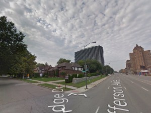
One block east off of Jefferson Ave., in Detroit.
d to talk about my book about race.
We began driving east on 7 Mile Road around 2:30. From Northville’s quaint shops, fine homes, and secluded apartments in park-like settings, we passed into Livonia, another wealthy suburb (Fun fact according to Wikipedia: Livonia is the whitest city in America among cities with populations 100,000 or more.) Livonia along 7 Mile is full of expensive, cookie-cutter homes, office parks, and home and garden stores catering to a higher-end market. Entertainment options abound: a golf course, soccer fields, a Dave & Buster’s games-and-overpriced-burgers place.
At Farmington Road, things begin to change. Suddenly the buildings are smaller, businesses older and more mundane: a barbershop, a heating and cooling repair place, an upholsterer. The houses are smaller single-family homes, older ones interspersed with new construction. A couple miles down the road, the parking lot of a big-box store is filled with carnival rides sitting still in the rain. Across the street is a dead strip mall.
At Middlebelt Road, the scenery turns to fast food joints and working-class taverns. The garden center here (“Bushel-mart”) is not selling organic, heirloom seedlings but bulk piles of mulch and gravel. Although we are still in Livonia (see: whitest city in America), we see our first wig shop catering to black women. We also note our first check-cashing place, as well as our first pawn shop. There is at least one liquor store every two blocks.
The sense of this area being a boundary between the suburbs and Detroit proper is visible on the street. I see a red pickup truck with a giant decal across the cab window, the Chevy logo embedded in a stylized Confederate flag. I also see a modest apartment building with subtle security mullions built into the windows. They are colored to blend in with the glass and white trim, as if to say, “We’re afraid but we don’t want to appear so.”
At Grand River Avenue, there is a weekly rate motel, a nail shop, and the glossy headquarters of the Detroit alumnae of Delta Sigma Theta, a powerful African American sorority.
Boarded-up businesses abound along this stretch of 7 Mile Road and some houses show signs of abandonment. Stopped at the light at Telegraph Street, I note the telephone poles are dotted with “Sell your house for cash” signs, a marker of a city still in foreclosure crisis.
There are no trees or parkways here. The dead factories and small shops are pulled up right to the road and in the summer there will be no shade for pedestrians walking the long distances between functional businesses. While a few churches are apparently doing well, as the soaring twin spires of the Greater Grace Temple suggest, many other churches are shuttered, as are a number of fast food and locally owned soul food restaurants. Auto collision and used tire shops are everywhere, but no new car lots.
One corner sports a new medical marijuana certification facility. In front of the one thriving strip mall I see a sandwich board on the sidewalk: “Family reunion and RIP photo shoots.”
In the stretch going east from Southfield, there is an almost imperceptible shift. There are small brick single-family homes, a couple banks, and shiny new CVS pharmacy. Doctors in private practice have hung out their shingles. The Greater Emmanuel Institutional Church seems to watch over the area.
Then at Livernois Avenue, everything is transformed. For a short stretch, the homes get more expensive, with green yards full of spring flowers. We see a Frank Lloyd Wright house and homes with elegant slate roofs. A sign advertising tai chi classes is stuck in the grass at the edge of a park. Boldly colored “Yes on Proposition 1” political signs appear in some yards. A golf course shares a boundary with a police station.
The respite from the poverty landscape is brief, however. At Woodward, a mega-church sits amidst boarded-up businesses and auto repair shops. A string of vacant storefronts feature signs in Arabic offering Middle Eastern foods and Muslim-related goods. An old plumbers’ union hall is an abandoned hulk, its logo fading into the whitewashed wall facing the street.
We thought we had seen some impoverished neighborhoods along 7 Mile Road, but at the I-75 overpass things took a turn for the even worse. We realize that the car in front of us is an unmarked cop car, rolling slowly through the neighborhood. The public library has thick bars on its windows and every empty lot is full of trash — blown in from the street but also simply dumped in bags. Tiny single-family homes are in severe disrepair. The collapse is layered here: old banquet halls turned to storefront churches turned to board-ups. One of the more vibrant-appearing businesses is a local soul food restaurant; another is a medical marijuana outlet. A church seems to have expanded its empire to include a theological school and a strip mall of functioning businesses. But on many blocks, men linger in front of empty stores and apartment buildings with their windows busted out.
At Outer Drive East, bright banners announcing “Osborn Community” hang on the lightpoles. The board-ups here sport elaborate graffiti. A big high school rises up on the south side of the street. Osborn High School’s facade is hung with giant signs announcing the aspirations of the Detroit Public Schools. It’s school dismissal time and traffic slows. In front of the school a fight breaks out as we pass, two boys swinging at each other and shouting. I see the frightened eyes of the smaller of the combatants. He clearly doesn’t want to be doing this. A cop in his squad car parked in a driveway across the street doesn’t bother to get out, just uses his megaphone to tell the boys to break it up and they do. Apparently, nobody wants to be doing this.
We’re nearly at the end of 7 Mile Road. At Gratiot Avenue, we see an old building — the Professional Arts Building — with every window hollowed out. The building’s ceilings and walls are falling in — and sometimes out, like entrails of a road-kill animal. A sign on the telephone pole advertises “Help Wanted — $9.00 an hour” with no description of what the job might be. The advertisers seems to know that nine dollars apparently is enough of an attraction in and of itself.
At Kelly Road, 7 Mile ends, angling slightly to become Moross Road, a wide boulevard bordered by small, red brick homes. A little ways down, a sturdy sign announces “Future site of Moross Greenway Project” with a website for more information. Suddenly, the brick houses are in better repair. St. John Hospital and Medical Center dominates the neighborhood, an L.A. Fitness gym and a Walgreen’s at its feet.
By Mack Avenue, the scenery has completely transformed. Large yards with mature trees surround modest-sized middle-class houses of diverse design. A soccer field and wide parkways offer green space to play. The Grosse Pointe United Methodist Church’s multi-story stained glass window doesn’t require any security mullions.
From there, we turned down Lake Shore Drive. Heading toward downtown, we passed the opulent houses and sailing clubs of Grosse Pointe and into the working-class neighborhoods of Jefferson Avenue surrounding the windowless Chevrolet assembly plant. Just before downtown, new condos with nice cars parked in front and tall apartment buildings line the harbor area on the east, while street after street of abandoned, boarded-up and sometimes burned-out homes stretch to the west.
The harsh contrast on our left and right brings a “What the fuck, America?” out of me.
I almost never swear but there is no other appropriate reaction to the shocking disinvestment in whole neighborhoods full of real-live people. What the fuck, America?